Navigation: Index page
Of all the 14ers in Colorado that I have climbed (about 18), the one of which I have the fondest memories was Mt. Harvard (14,420 - third highest - climbed in 1989 with Joan). For years, I have wanted to do it again. At 72 in 2021, I was starting to slow and was wondering for how much longer I would be able to do such a trip. So I determined to do it this year. I wanted to wait as late as possible to avoid snow issues, but had to go before July 6 when I started two months of radiation treatments (successful). Joan didn't want to go and I didn't ask anyone else so I was alone other than the rather large number of other parties on the trail. Interestingly, it seemed like most were women, many were alone, most had dogs and all were much younger than me.
On Thursday, I drove from home in Socorro to North Cottonwood
Canyon and found a dispersed camping site. The next day, I hiked to
Horn Fork Basin near timber line and camped at a well used site. On
Saturday, July 3, I climbed Harvard with a 4:30 am pre-dawn start as
we were in thunderstorm season and there were storms on Friday. I was
on top before 9 which is not fast but I made it and was feeling good.
I spent a total of 9 hours away from camp, including a diversion to
Bear Lake for a siesta on the way down since the weather remained
good. I stayed at the same camp for a second night since it was nice
there and I didn't relish trying to find an unoccupied campsite with
the car in the middle of July 4 weekend. I got up fairly early Sunday
for the hike out and drive home, arriving at about 5 pm.
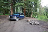
My dispersed camping site near the trailhead. There was a sizable stream nearby. When I walked over to it, I saw a couple of otters. |
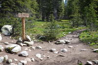
The trail leaves the Kronenke Lake trail after about 1.5 miles. Then over the next couple of miles, there are a couple of trails that head up Mt. Columbia. |

After about 4 miles, Mt. Harvard comes into view above the Horn Fork Basin. |

Soon you come to an area with many well used campsites near the tree line. |

The weather was a bit threatening even near noon so I set up my tent. |

Mt. Columbia behind camp. Later, to get the view, I went up the prominent rock outcropping right of center in this photo. |

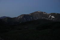
Mt. Harvard from near camp. The trail goes close to straight to the peak, which is the shaded one to the right of center in this photo. There is a horizontal snow field just below the top. |

The view toward camp from the rock outcropping. My site is in the trees near the lower left corner of this photo, near where a visible trail goes down to a small creek. The main trail is to the right. |

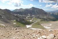
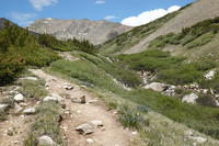
The upper Horn Fork Basin. Parts of the trail are visible in the foreground. The trail then goes up the basin to the left of the spur ridge, then over the visible saddle in that ridge. It then makes its way out of sight behind the spur to the final Mt Harvard ridge, which it follows to the summit. |

This is a wide angle view of Horn Fork Basin and Mt. Harvard from the rock outcropping. |

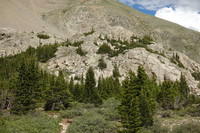
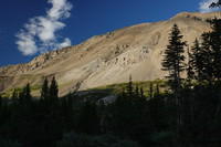
This is the side of Mt. Columbia showing a portion of the new trail, whose upper reaches were still under construction in 2021 as far as I know. |
Looking back at the rock outcropping after climbing it. |

Mt. Harvard from near camp. |
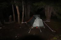
My tent as I started the ascent before dawn. Taken at 4:22 am. |
At 5:18, it's starting to get light. I believe this is looking back at Mt Yale, another of the Collegiate Peaks 14ers. |

Lots of flowers. |
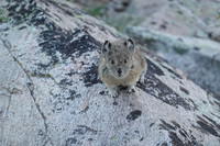
I suspect that this pica has been fed before. He got quite close. |

The top is about where the sunlight on the ridge ends. The trail works it's way to the ridge between the larger snowfields on the left, then goes up the ridge. |

This is now on the ridge. The trail is out of the frame. |
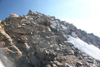
The final scramble to the summit is over these blocks. |

On top at 8:42. That's no record, but I made it. |

Looking back down the ridge. Bear lake is visible. My camp is right about at the tree line on the left edge of the picture. |

Somewhat longer focal length shot of Bear Lake and Horn Fork Basin. Again, camp is just into the trees on the left side of the valley. The rock outcropping I visited is sunlit above camp, looking rather small from here. |

Looking north from the summit. The next ridge has Mt Oxford near the right side of the photo and Mt Belford left of center. Both are 14ers. The high mountain in the distance to the left of the Mt. Oxford summit is Mt Elbert, the highest in Colorado. The tall peak in the distance near the left side is, I'm pretty sure, La Plata Peak, one of the taller 14ers. |
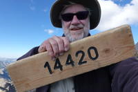
Me holding the sign. This is the other side of the one in the first summit photo that says Mt. Harvard. |

Starting the descent through the scramble section. |

A wide shot down the ridge. Here you can see the trail which even here, just below the summit, is as good as any of the trails in our local Magdalena Mountains. |
Mt. Columbia and the upper Horn Fork Basin |

Bear Lake. When Joan and I did Harvard in 1989, we camped near the lake. |
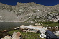
On the shore of Bear Lake. I took my siesta near here. |
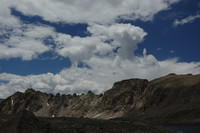
Looking at the rugged ridge above Bear Lake with clouds. |

More flowers. |
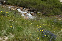
Flowers and a small stream along the access spur trail to Bear Lake. |
The trail not very far above camp. |
Mt Columbia from close to camp in the evening. I was back at camp before 2pm. |
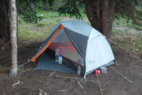
My camp. Everything is well staked out because of the possibility of thunderstorms while I was not around. |

Evening shot of Columbia from camp. |

I was off by about 6:30. This is the trail after rejoining the Kroenke Lake trail. |
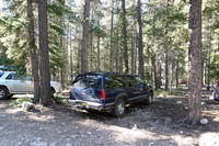
Yes, my car was still there. I got to it about 8:13 am and started the drive home arriving about 5 pm. |