Navigation: Index page
The page contains scans (actually photos) of the slides that were not selected for the main show about the 1975 First Ascent of the Northeast Ridge of Mt. Vancouver in the St. Elias Range, Yukon Territory.
As of Jan 11, 2026, the only photos here are ones that include Mt. King George. The intent is to make these slides available to the Yukon Geological Society in response to their request for photos from before the Dec. 6, 2025 earthquake that caused a number of avalanches and rock slides on King George.
Note each slide has a number like B104S20. That means that it comes from little yellow box number 104 and is slide 20 in that box. This is for my internal bookkeeping. Eventually there will be a lot of slides here. The main slide show fills a 140 slide carousel tray and it only contains about a third of my photos from the trip. Since this was arguably my most significant trip, I plan to digitize all of the photos eventually.
The slides were digitized in January 2026 using a Pentax K5 DSLR with
a 100mm macro lens. The camera on a sliding stage, the film holder from
and old film-based slide duplicator, and a Negative Supply Light Source
were all mounted on a piece of angle iron. The original photos were taken
with a Konica Autoreflex T3 on Kodachrome.
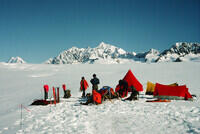
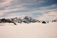
B104S20 Looking at Mt. King George from Base Camp below the NE Ridge of Mt. Vancouver |
B104S32 Looking toward the southeast ridge of Mt. King George from just below base camp. |
B106S03 Base camp, missing the big tent, looking toward Mt. King George. There is a characteristic glacier on the SWS side of the summit of Mt. King George that clinches the identification in many cases. |
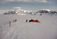
B106S34 Mt. King George and Mt. Queen Mary seen from somewhere not too far below our advance base camp (Camp 2). This was probably taken from our probe of a route on the north side of the ridge that we eventually decided was too dangerous to use. |
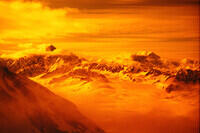
B106S35 This is essentially the same photo subject as as the last one and the clouds suggest it was taken very close in time. It looks like spectacular alpenglow or sunset, but the sun angle is wrong for that. Maybe I took the photo through my goggles. |
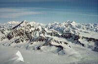
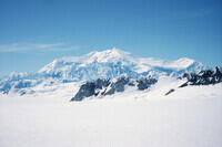
B108S08 Mt. King George with Mt. Queen Mary to the right. The high peak in the distance behind and slightly left of Mt. King George is Mt. Lucania |
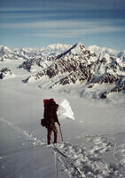
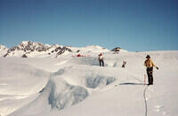
B108S10 Hal Murray along the cornice looking toward Mt. King George from the same location as the previous photo (same bit of cornice visible). |
B109S06 Looking toward Mts. King George and Queen Mary from the summit of Mt. Vancouver. In the full resolution scan, there is a thin blue horizontal line near the center of the photo. That is there on the original slide. Maybe it's a scratch. Anyway, it is not an artifact of the digitization. |
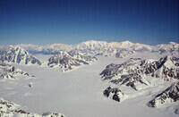
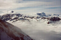
B109S07 Looking up the Hubbard Glacier from the summit of Mt. Vancouver. Mt. King George is at the right edge of the photo. |
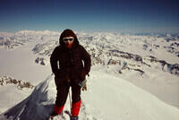
B109S23 Me on the summit of Mt. Vancouver. The peak of Mt. King George is directly behind me, but the ridges can be seen. |
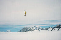
B111D15 I have no more photos of Mt. King George taken from the climb. This photo shows Mt. King George in the background as the helicopter taking out our climbing gear and two member of the party it taking off. |
B111S19 Another photo at about the time we left for our hike out from base camp to the Alaska Highway. A ridge on the west side of Mt. King George is visible on the right side of this photo. |
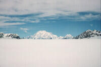
B111S33 From base camp, we went approximately due north for about 17 miles before turning toward the Kaskawulsh Glacier. This photo of Mt. King George was taken part way along that northern leg. |
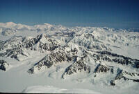
B112S08 Mt Vancouver as seen from the hike out. The rocky ridge in the foreground is the SE ridge of Mt. King George. |
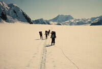
B112S21 This photo was taken just after turning the corner toward the Kaskawulsh Glacier. The mountain above and slight right of the skiers is Mt. King George, seen from the north west. |