RETURN TO PREVIOUS INDEX
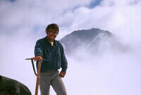
During the summers of 1967 and 1969, after my freshman and junior years at UCSD, I worked on glaciology projects under Dr. Barklay Kamb of Caltech. The goal was to study the flow of the ice over bedrock. The studies were done on the Blue Glacier on the side of Mt. Olympus in the Olympic National Park in the state of Washington.
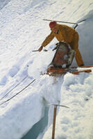
In 1967, we dug a tunnel horizontally in an ice fall to try to reach bedrock, taking advantage of the steep angle of the glacier at that location. This was a joint project with a University of Washington team led by Ed LaChapelle and including Will Harrison. The tunnel was dug with the help of chain saws, jack hammers, and ice picks. We reached a region with lots of rock in the ice, but I'm not convinced that we were actually at bedrock. Any relative motion was very small. I'm having trouble remembering the length of the tunnel or finding any records, but it was well over 100 ft. About a third of the way from the end, we dug at nearly right angles to the left trying to identify the cavity that had been causing reverberations while digging. We had not gone far when we hit a huge cavern between the ice and the mountain. I believe we could have climbed out from under the glacier along its side via that cavity. Instead of subtle melting and refreezing as the ice flowed over rock obstructions, the ice peeled off in big "jelly rolls".
In 1969, Barklay wanted to study the flow over bedrock in a somewhat less dramatic setting, down on the much flatter part of the glacier. A tunnel was not practical because of both the angle (a downhill tunnel might fill with water) and the thickness. So we used hotpoints (powered by an electric generator) about three inches in diameter to melt bore holes through the ice. The idea was to melt one hole all the way to bedrock. Then melt another to within about a foot of bedrock next to it (depth predicted from the first hole). Then melt a narrow hole the rest of the way to bedrock at the bottom of the second hole. The speed of the flow would be determined by photography of the rocks going by in the first hole. The relative importance of melting/refreezing vs deformation would be determined by changes in lengh of the small hole. We had several pairs of holes. The hitch was that the bottom meter or more of ice was full of silt and rock which insulated the tips of the hotpoints. We ended up melting large cavities at the bottom of the holes when the hotpoints slowed down drastically. The photography still worked and we got speed measurements, but the small hole scheme did not work as I recall.
The hotpoints were at the end of a pipe roughly 2m long. While preparing to lower the assembly, there was a short time after lining up the pipe in the hole and before the cables were attached when it was possible for the assembly to slip out of ones grip and fall, untethered, into the hole. That generally meant the hole was blocked and the hotpoint was lost, which was not good because they were not cheap. I did that one day. Barclay wasn't happy and I was quite annoyed at myself. But I managed to cobble together a Rube Goldberg device with nails, rubber bands big washers and other items in our supplies that could grab the top of the pipe by sticking nails into the hex holes of the set screws holding the cable connectors to the top. After much testing with an extra hotpoint, I tried it on the one at the bottom of the hole. After several tries, it worked! Barclay was quite interested in my device after I pulled up the lost hotpoint.
One of the other people working on the project in 1969 was Steve Russell, a friend of mine from UCSD. During both summers, we had an occasional day off (one per week, as I recall). We would usually use that day to climb nearby peaks or explore glaciers in other valleys. On one day, Steve and I used the time to explore the lower part of the Blue Glacier where the bare ice was exposed. Our work areas were in the accumulation zones where the top layers were the previous winter's snow accumulation. We did not leave the mountain during either summer so we were pretty isolated for the month in 1967 and 3 months in 1969. Our reintroduction to civilization was somewhat cushioned by the fact that the first people we ran into in 1967, at a camp just off the glacier, were celebrating Bilbo Baggins' birthday.
There is a hut on the Snow Dome on the side of Mt. Olympus, near the top of the Blue Glacier, that is used to support glaciology on the mountain. That is where we stayed the first summer. Each day we would hike (actuall glassade most of the way) down to the ice fall work area. At the end of the day, we would trudge back up. It was about an 700 ft elevation difference. There were a total of 11 people there the first summer. The second summer, Barklay's team, which was now something like 5 or 6 people, camped on a moraine along the side of the glacier much closer to the work area. That avoided a lot of time getting back and forth to the work sites. During both seasons, supplies were flown in by ski plane. Several flights were required to start the season, then there was a flight about once a week.
There was a major event in the outside world during the 1969 season - the first Moon landing. A television was flown in to the hut by the University of Washington crew at the Snow Dome to allow both crews to see the landing. For this, we took, as I recall, 3 days off to hike up to the cabin and watch the coverage of the landing and the Moon walk. Barklay was not too happy about the lost time, but did not prevent it and did join us for the crucial few hours. This was something the rest of us really did not want to miss. There is a photo in this set of the Moon over Mt. Olympus taken during the time Armstrong and Aldrin were on the surface.
The photos here were taken with a WWII vintage Leica rangefinder camera that my father, from what I heard, acquired from one of the first American soldiers to reach the Leica factory. Its serial number indicates it was made in the final months of the war. It had a light leak that I had pretty well sealed, but still shows up barely in a couple of the photos. This is a quality but basic camera. You can get an idea of all the available functions from the fact that it does not have a battery so there isn't even a light meter. It also has a fixed focal 50 mm lens. Some of the photos suggest I had another focal length available, but I forget how. There are pictures of the camera and its case, which I still have, as they are in October 2025, at the end of the show. They have had a rough life.
The film was Kodachrome II, whose archival qualities allow the photos digitized in 2025, nearly 60 years after they were taken, to look little different than they would have if they were taken yesterday. I digitized the photos using my Pentax K5 DSLR, a 100mm Macro lens, a slide holder and frosted glass from a film era slide duplicator, and a desk lamp with an LED bulb with adjustable color temperature. The setup is shown in a photo at the end of this set. I used the Gimp to crop the images, tweak the color balance and get rid of the occasional offensive piece of dust. With all the snow, the results are very sensitive to color balance.
I have identified the locations of many photos by comparison with Google Earth, using the ability to pan around and zoom in and out to try to duplicate backgrounds.
I found a reference to a paper that may be for the 1967 work, but I have not located a copy I can read: Kamb, B., E. R. LaChapelle, Flow dynamics and structure in a fast-moving icefall, Trans. AGU, 49, 312, 1968.
A picture from the project is at: https://www.semanticscholar.org/paper/Classics-in-physical-geography-revisited-Knight/0a8a67ac8930b73857544cb66c3e3d6c22c1e226/figure/1
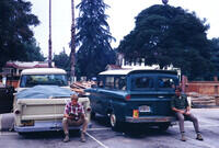
Preparing to drive from Caltech to Port Angeles. I'm a bit confused because I don't remember a pickup and I do remember an International Harvester suv (although that name had not yet been invented). Perhaps the pickup went ahead with its load of supplies. That IH vehicle drove like it had a rubber steering column. I eventually refused to drive it. The other broke a drive shaft on the freeway in Portland. We pulled the broken bits, put it in 4WD (now front wheel drive) and drove it to Port Angeles like that. I may be mixing up 1967 and 1969. |
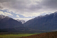
Driving up US 395 through Owens Valley. This is the view of Mt. Whitney from close to Lone Pine. It is probably taken from very near where Ansel Adams' famous "Winter Sunrise, Sierra Nevada from Lone Pine, California (1944)" photo was taken. I grabbed my camera as we drove past. He spent days waiting for perfect conditions. The difference shows. Of course, there's skill too.... |
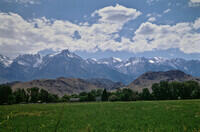
From the Sherwin Grade north of Bishop looking toward Pine Creek in the Sierra Nevada Mountains. |
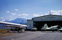
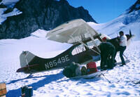
The airport in Port Angeles. Note the skis on the small plane to the left. That is our supply plane. |
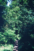
We hiked to the Blue Glacier by way of the Hoh River. This is rain forest with an annual rainfall of around 140" or more per year. |
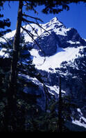
A view of Mt Tom from the Hoh River Trail. |
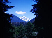
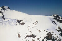
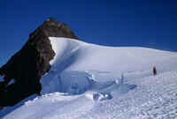
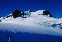
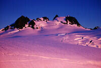
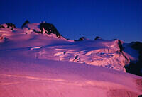
A view of the ridge leading to Mt Olympus from the north. The smooth snow to the left of the peak is the Snow Dome. The research hut where we stayed is about in the visible saddle. |
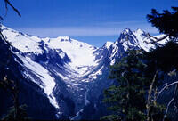
From fairly high on the trail, looking up Glacier Creek to the White Glacier and Mt. Tom. |
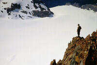
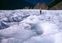
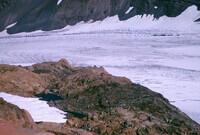
About to get on the ice on the Blue Glacier. Comparison with Google Earth images taken in 2025 suggest there has been considerable melting. |
About to cross the Blue Glacier and head up to the Snow Dome. |
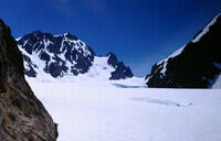
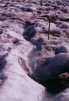
Looking up the Blue Glacier to where we will be digging the tunnel in the ice fall. Our work site will be just to the right of the rock cliffs in the middle of the ice fall. In larger versions of this photo, you can make out some tracks leading up the icefall to where some exploratory hotpoint holes were used to determine the depth. |
The crew heading in. Unfortunately I do not remember their names and have not yet found records. |
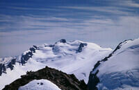
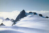
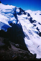
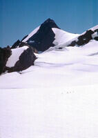
Mt Olympus (West Peak) as seen from the Snow Dome. |
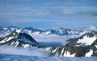
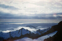
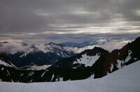
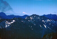
Looking generally NE from Mt Olympus toward Burlington and Mt. Baker |
Looking about north from the Snow Dome in the general direction of Victoria, I think. |
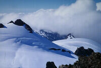
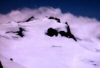
Looking toward the Mt. Olympus summit and the region a bit to the west from the Snow Dome. |
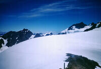
Looking generally west from the Snow Dome. |
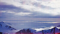
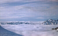
Looking toward the Pacific Ocean, I think. |
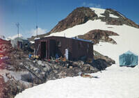
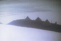
The research hut at the edge of the Snow Dome, where we stayed in 1967 and where we watched the Moon landing in 1969. |
Ed LaChapelle, the PI from the University of Washington. He went on to become a well known avalanche expert. |
I believe this is Will Harrison and his wife Anne who served as cook for the everyone. But I may be completely wrong on the identification. Will Harrison's obituary suggests he was climbing Mt. Logan in 1967 and the timeline of his entry to glaciology is more consistent with him being in the 1969 party. |
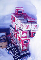
We had a good supply of beer! When living on the edge of a glacier, it is not hard to keep things refrigerated - just dig a snow cave. |
Our supply plane landing on top of the Snow Dome. Sorry about the poor focus. |
To take off from the top of the Snow Dome, the pilot taxied to the edge, turned the engine to idle, and let gravity do the work. |
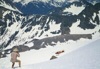
And gravity did a good job. The plane here is well blow us, but flying. |
This is the path to the landing area. I guess the two people are stringing a cable to the landing area for communication, but I don't remember anything about that. |
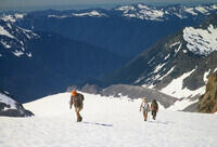
Ed heading down to the work area. There was about a 700 ft elevation difference between the hut and the tunnel. |
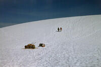
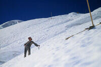
One of the others heading for the work site, which can be seen in the lower left of the photo. The tunnel was uphill from the obvious tent. The morning commute was a long glassade. Looking back, it seems a bit crazy, but there were crevasses. If you felt a foot start to go through while glassading, you took a forward dive which put you beyond the crevasse. |
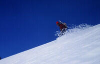
Someone having a good glassade. Note we did standing, not sitting, glassades. It feels a lot like skiing. |
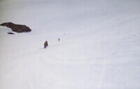
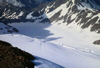
Looking down on a couple of glassaders. The tracks from the bottom of the glassade to the work site, and the return track a bit lower, are clearly visible. We got quite upset if someone went down the up track and wiped out the steps. Occasional climbers did that. |
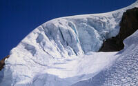
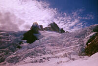
The Blue Glacier icefall with the tunnel uphill from the tent. Occasionally a threatening serac above the work site would get dynamited. |
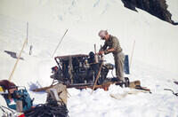
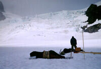
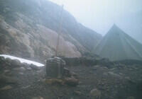
We were using power tools to dig the tunnel. But in a tunnel, you don't want to be running gas motors. So we had this machine. I'm pretty sure it was a compressor and the tools were pneumatic, but for some reason I'm not remembering clearly. This would have been down by the tent in the previous photos. |
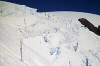
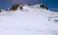
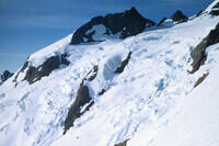
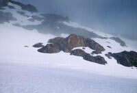
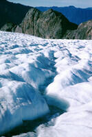
Looking across the icefall from the tunnel entrance. The part we were in was much less active than what is seen here. The stakes mark survey points helping to measure the flow of the surface. |
Looking uphill from the tunnel entrance area. |
The digging was done by a crew of 6. One would make the cuts diagonally outward on the face of the tunnel with the chainsaw, then chip out the wedges on the sides with a pick or jackhammer. Then the jackhammer would be placed in the middle of the face causing the whole thing to shatter. That got you about a foot of new tunnel. The second person would then shovel the newely freed ice and put it in the sled shown here. The third person would take the sled to the tunnel mouth and dump it. The other three people would be resting. At some interval I forget, we would rotate. Barklay thought that was too much resting, until he tried it. |
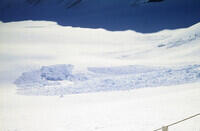
This it the result of a significant avalanche that we witnessed on the other side of the rock ridge in the middle of the icefall. It was impressive to watch it falling. |
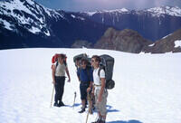
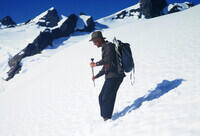
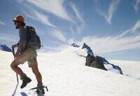
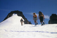
I think we are preparing to go for a climb on a day off. |
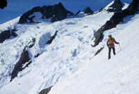
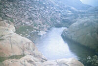
This is on the Blue Glacier below the icefall. |
This looks to be taken from a summit. An attempt to match the view using Google Earth suggests that it is the peak called Mercury on Caltopo that is along the east side of the Blue Glacier. That would explain why we are low on the glacier in the previous slide. |
This does indeed match the Google Earth view from the top of Mercury toward Mt. Matias and Mt. Athena. |
And this is the view from Mercury toward Mt. Olympus on the left, the Snow Dome in center right, and the saddle where the hut is located on the right skyline. |
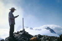
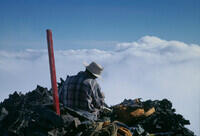
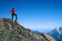
This presumably is on the summit of Mercury. |
This is likely along the ridge from Mercury to Mt. Mathias. |
Heading up Mt. Mathias I believe based on the summit photo after the next. |
Probably heading for the top of Mt. Mathias based on the next photo. |
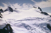
Based on Google Earth, I think this is taken from top of Mt. Mathias looking toward Mt. Olympus main summit on the right and Middle Peak on the left. |
Again this view from the top of Mt. Mathias matches Google Earth, except that most of the ice in the general direction of the hut at the right end of the Snow Dome is now gone. |
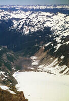
Looking down at the foot of the Hoh Glacier from Mt. Mathias. The Google Earth view from 2025 shows the foot of the glacier near, or maybe even off, the bottom of this photo. It has retreated a lot. |
Looking toward Mt Athena from Mt. Mathias. |
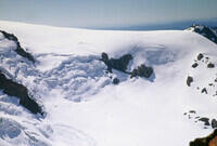
Looking down on the Blue Glacier from Mt. Mathias. |
Hanging around the rest area next to the tunnel mouth in the Blue Glacier icefall. |
Barclay Kamb taking a picture near the tunnel mouth. |
Inside the tunnel clearly wanting a tripod. The tunnel face was about the size of an ordinary door. Overnight, the ice deep in the tunnel would try to close. The walls would move inward a couple of inches. You didn't want to leave tools leaning against the wall as they could get trapped and require chipping out. I gather some of the highest strain rates ever measured at the time in ice were measured in the tunnel. |
The tunnel face again. After the chain saw cuts were made, one on each side and top and bottom, a pick was used to remove the wedges along each side. This shows the pick being used on the top. |
Dumping a load of ice at the mouth of the tunnel. The large blocks suggest that this was from a the final shattering of the face after the side wedges were cut. It also shows that there was a lot of erosion caused by the dumping and I think there may have been a crevasse right below the dump spot. There is a chance that this is me. |
Occasionally, someone lost control of the sled while dumping resulting in it rolling down most of the way to the tent. |
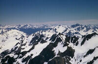
Looking generally north east from the Snow Dome. |
Somewhere among the peaks of Mt. Olympus on the way to the East Peak. I'm not exactly sure where. |
This aligns with Google Earth best if it is from the East Peak of Mt. Olympus. There are alignment problems if it is from the Middle Peak. |
The summit of the East Peak of Mt Olympus, looking over at the West Peak, which is the highest. The alignment of the various subpeaks is different from that of the next photo, which I think is taken from the Middle Peak. Also note the white pole. The next summit photo that shows a red pole, so is of a different (Middle) peak. |
This photo seems to be taken from the Middle Peak based on the Google Earth alignment. From the East Peak, the summit behind the West Peak is not nearly as visible. It looks like we climbed both summits that day. |
Looking down at the Snow Dome and the hut from the Middle Peak. This is clearly not from the East Peak. |
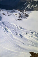
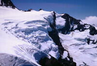
Looking down on the Blue Glacier from the Middle Peak of Mt. Olympus. |
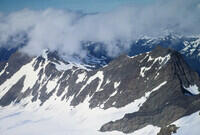
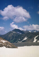
Summit photo with a red pole. This is probably the Middle Peak. It is certainly different from the previous summit photo. Note the clouds below the peaks - a very common condition in the early summer. |
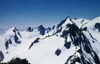
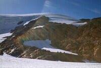
Looking at Mercury and Mt. Mathias above the Blue Glacier from the Middle Peak of Mt. Olympus. |
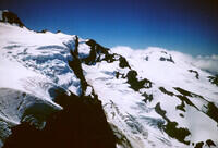
Looking up at the West Peak of Mt. Olympus, the high peak, from the route back to camp. |
Looking back at the Middle Peak of Mt. Olympus from the route back to camp. |
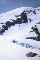
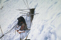
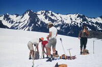
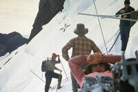
At one of the hotpoint drilling sites above the tunnel, trying to figure out why the tunnel hadn't hit rock yet. It turned out we were running somewhat parallel to the rock face. The site with the tent is probably actively drilling while the other are just getting probed occasionally. |
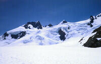
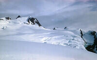
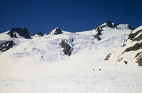
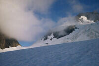
Looking up at the glacier on the other side of the rock rib. |
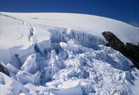
Looking over at the very active part of the icefall. We avoided that area. |
Getting a hot point ready. Or it could be a camera or other probe. |
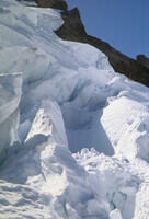
Over in the active part of the icefall. Someone clearly went into it to install the marker. |
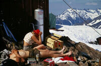
One evening, we had a huge dinner of steaks and, I vaguely recall, beans. The next day, we had tremendous energy. |
Looking up at the Mt. Olympus from the hut at the Snow Dome. |
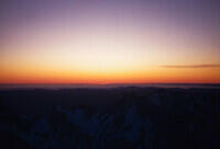
A final sunset shot from the 1967 trip. Several times we looked for the green flash, but I was never convinced we saw it. |
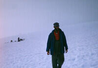
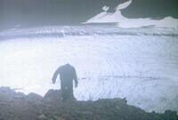
We had rather dreary weather at the start of the 1969 session. In fact the weather held back our initial supply flights for several days and prevented us from getting started. That about drove Barklay crazy. I'm pretty sure this is Will Harrison. |
A supply cache on the glacier, probably near the landing zone. |
Looking back from the work area to the side of the glacier. |
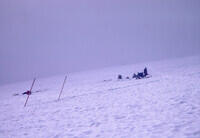
Another shot along the line of drill sites. I'm not sure why the poles are tipped - I don't think there is a serious level issue with the photo. |
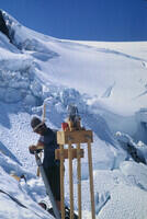
Steve Russell at one of the drill sites. I forget the reason for the water system. Perhaps it was cooling because we ran a fair amount of current into the hotpoints. |
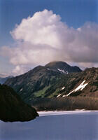
Steve Russell and one of the adjacent peaks, probably Mercury. |
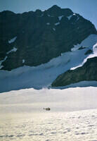
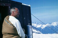
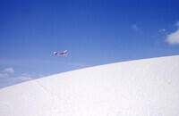
A Coast Guard rescue helicopter on the Blue Glacier below Mt. Mathias. I think it was a training mission concerned with glacier operations. |
A much closer shot of the helicopter as it came to check us out. I don't think it landed, probably because of the slope. |
Looking down glacier from the work area. I'm not sure if the two people are from our party or are other climbers. |
Looking from the work site up at the pass between Mt. Mathias and the East Peak of Mt. Olympus. |
Looking down glacier in evening light, probably from our camp on a moraine to the side of the glacier. |
A similar photo to the last with different orientation. |
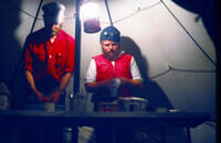
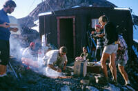
Looks like dish washing time. |
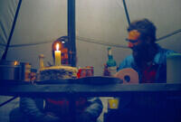
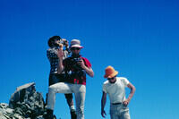
I suspect that this is someone's birthday. Not mine. |
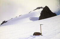
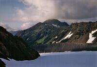
Mercury in evening light. |
This is the view along the side of Mt. Olympus from near the hut on the Snow Dome looking a bit south of due west. We went to the hut to witness the first Moon landing and Moon walk. The following pictures were taken while we were there. The University of Washington group had flown in a TV. I think our signal was from Victoria. |
Another WSW view from near the Snow Dome hut. |
Yet another WSW view from near the Snow Dome hut. |
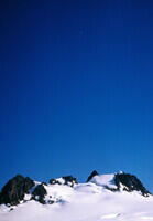
The view from the little peak behind the hut on the Snow Dome. Caltopo shows the name Panic Peak on this feature. This shows the hut, something in the landing area on top of the Snow Dome, and a party of climbers, probably not from the research groups. |
This is likely Mt. Tom which is west and a bit south of Mt. Olympus. |
A view over Stephen Peak (closer) to Mt Baker in the distance. This photo has the "comet tail" light leak in the lower right that establishes for sure that it was taken with the Leica. But it also has a field of view indicating the use of a telephoto. Or maybe I was shooting through binoculars. |
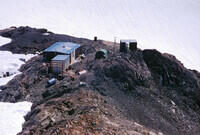
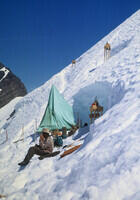
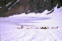
The research base at the Snow Dome in 1969. The small building to the right contains the latrine. One evening, we had 11 people and a desert divided into 12 pieces (much easier than 11). Cards were drawn for the extra piece. What was left unsaid was that the person who won also got the duty the next day of cleaning the overfull latrine. |
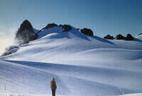
The climbing party on the Snow Dome with the Middle Peak of Mt. Olympus in the background. |
The view probably from Panic Peak toward Mt Carrie and, not really visible in the far distance, Victoria. |
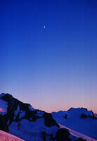
The view from near the hut to Mt. Olympus with the Moon overhead. This is particularly special because it was taken during the Moon landing. There are people on that Moon! |
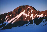
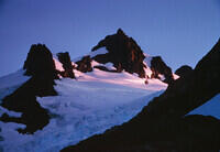
Alpenglow picture of Mt. Olympus from the research hut. |
Another of the moon and the side of Mt. Olympus and Mt. Tom on the day of the Moon landing. |
A later alpenglow photo of Mt. Olympus. |
The East Peak of Mt. Olympus from the hut area. |
Rainy weather back down near our camp. Along the side of the glacier. |
The toe of the Blue Glacier in poor weather. |
Someone hiking up the rocky area above the bottom of the Blue Glacier in poor weather. |
Looking over the toe of the Blue Glacier from somewhere below the Snow Dome. Most of the ice in this photo is now gone. |
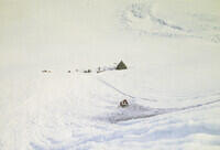
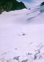
Our camp on a moraine on the side of the Blue Glacier on a dreary day. |
Another of camp. |
Looking from out on the Blue Glacier toward camp on the moraine and the Snow Dome. |
Looking down the glacier toward the Hoh River valley. |
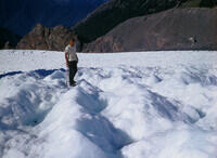
On one of our off days, Steve Russell and I decided to go to the lower part of the glacier there was net melting over a year (ablation zone) and where bare ice was exposed. It is quite different from the accumulation zone where we were working and climbing. This shows one of the small streams running over the ice. |
Steve photographing a stream on the ice. |
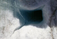
The streams eventually find a weakness in the ice and plunge to the bottom through a moulin. These can get quite big and are one of the hazards in parts of the glacier where they might be covered by a snow bridge. |
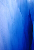
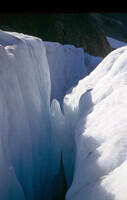
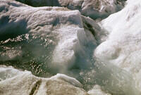
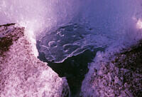
A crevasse. This photo emphasizes the blue color of the ice inside the glacier. |
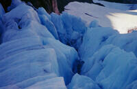
Some of the ice structures near the side of the glacier where the stresses of going around a corner have opened cracks. |
Steve on the lower glacier. On a sunny day, the ice is cracked and not slippery. In rain, you really want your crampons. Ropes are not really needed where the ice is bare, but you must not step on anything that looks like snow - it probably covers a hole or crevasse. |
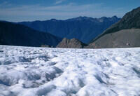
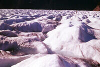
Some parts of the glacier would be very hard to navigate. |
Another surface stream. |
A flatter part of the lower glacier without crevasses. |
More streams. |
Yet more of the lower glacier in the ablation zone. |
Yet more streams. They are everywhere where there aren't crevasses on the lower glacier. |
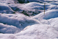
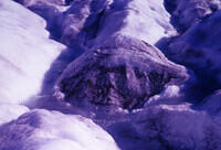
It must have been cold enough to freeze water recently as this appears to be a frozen surface on a puddle. |
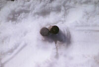
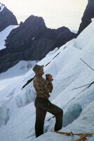
Back to the work area, some of the hotpoints are reaching the bottom of the glacier. The one on the left has encountered the mud in the bottom couple of meters. The clean one on the right is for comparison. |
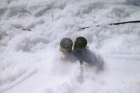
A different view of the two hotpoints. |
A look at the line of drilling stations from somewhere near camp. The saddle in the background is the one going to the Hoh Glacier between Mt. Mathias and the East Peak of Mt. Olympus. I'm a bit surprised that the trail from camp to the work area is not seen. |
A part of the lower Blue Glacier from the side, well above the ice. The cairn about dead center likely marks one of the survey stations from which the glacier surface motions were monitored. |
Looking up toward the Mt. Olympus summit from near the lower glacier. |
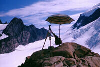
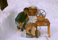
The surface motions were monitored by theodolite from several stations along the side of the glacier. This is one such station with the pass to the Hoh glacier in the background. The umbrella kept the direct sun off the tripod legs whose length is a bit temperature sensitive. I gained an appreciation for how difficult it is to measure angles to 10 arcseconds. Later in my career, I would be measureing angles to 10s of microarcseconds with VLBI with very different techniques. |
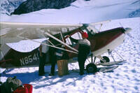
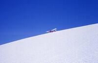
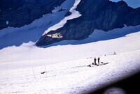
Our supply plane. It turns out it is difficult for a pilot to tell how far above a featureless snow field he is while landing. One of the pilots was always very nervous about it and one day misjudged and damaged the landing gear and a wing. Parts were flown in and the plane was repaired enough to leave. That pilot had never pranged a plane in thousands of hours of flying. We thought he might not be back, but actually he got much more relaxed about it and did most of the flights after that point. |
Another of the plane. While it was being repaired, we got some supplies in when the flight service landed a float plane on the Snow Dome. That worked ok except he had trouble stopping. |
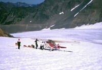
Yet another view of the plane. After the flight which had damage, we had some tar paper squares about 4 ft on a side brought in which were placed along the landing area. That gave the pilot enough height reference to avoid more trouble. Note here that the "runway" is rather sloped so you can't just level off and set down gently. You have to fly parallel to the ground when landing. |
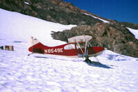
There he goes, with a significant gravity assist. The silvery colored area near where the landing gear attaches to the plane is the not-yet-painted repair. |
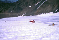
About to lift off. |
The plane in the air and headed home to Port Angeles. |
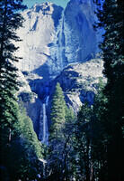
Yosemite falls. I'm not quite sure why this photo ended up in the slide carousel with the Blue Glacier slides. I think it might have been from a trip later in that year. Note that these older slides sets were edited and placed in carousels back near the time of the events occurred, but are only now, decades later, being digitized. I'm not second guessing the original editing. |
DIGITIZATION SETUP AND CAMERA
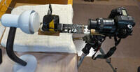
This is the guts of the setup I've been using to digitize slides. When in use, there is also a black tube shielding the space between the camera and the slide holder to minimize stray light. I also drape a black cloth over the light fixture and the slide holder to keep from blinding myself when I'm positioning the slide holder. The photos cover a bit more area then the actual slide which gives room for shifts and rotations in processing without loss. The slightly smaller field does not hurt the resolution because the digital camera is sharper than the slides. The light bulb has a color temperature switch that is set to 5000 deg. |
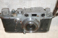
The Leica camera used to take the photos in this set as it exists in October of 2025 - 58 years later. It has had a hard life. The glob of junk on the lever just in front of the shutter button is a crude scheme to stop the light leak mentioned earlier. |
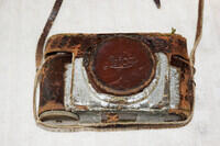
The case for the Leica in the last picture. I used this for a long time including on rock climbs and other activities where it took a lot of abuse. |